Anglers and Divers: See More… Faster
[print_link]
Supercharge CMOR Mapping’s remarkable high-resolution seafloor maps with Raymarine power and speed
The best diving and bottom-fishing spots are the ones that don’t show up on paper or digital charts and aren’t marked on commercially available fishing maps. They’re the forgotten wrecks, the isolated reefs, the ledges hidden between the contour lines — the kinds of places that take hundreds of hours on the water and countless dollars in fuel to find.
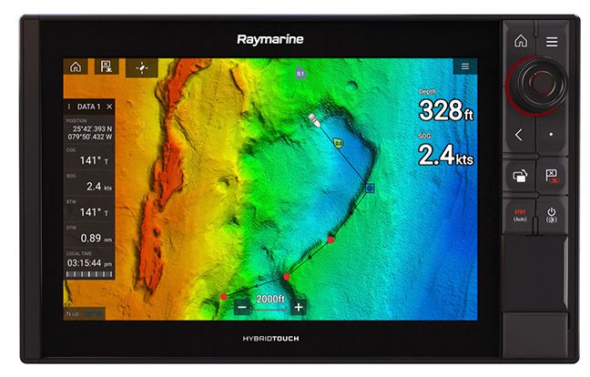
CMOR Mapping’s chartplotter-compatible bathymetry clearly reveals those spots. With resolution as high as one meter (each pixel represents a single square meter of bottom) and coverage of the entire bottom, anglers, divers and other treasure seekers can now see every bump in remarkable detail. And just as important, they’ll see the areas of featureless underwater desert – areas where they don’t need to spend time looking – just as clearly.
An initial look at CMOR Mapping’s charts reveals that traditional fishing maps are simply no match for this new era of charting. Users can explore the charts without leaving the dock and preplan trips by zooming in and revealing productive new spots for targeted species. This ability builds great efficiency – ultimately relieving users from wasted time and fuel – and results in more time catching fish.
Seamlessly Compatible
CMOR Mapping imagery is seamlessly compatible with most chartplotters, including Raymarine models running on the ultra responsive LightHouse operating systems. Installation takes under 20 seconds. Simply insert the Micro SD card (SD adapter included), select Chart from the LightHouse home screen, then Menu, Settings, and select the CMOR Mapping Chart option from the cartography tab. Zoom in on the desired coverage area to begin viewing CMOR’s incredibly detailed bathymetry data.
CMOR mapping utilizes your precise GPS location, unlocking the ability to view your vessel icon over the data, guaranteeing accuracy within centimeters of the bottom features on the chart.
All other vector data — tides, nav aids, routes, waypoints, etc. —remains available on your plotter and can be viewed as an overlay if desired. Put simply, a CMOR card adds another layer of extremely valuable data to what you already see on your Raymarine chartplotter.
Complete and Detailed
Most fishing maps and charts that show depth contour lines interpolate those lines from historical sounding data. In other words, the contours are drawn by looking at the measured depth at a number of points and then making educated guesses about what the bottom looks like between those points. In many cases, the results are fairly accurate. But isolated features — a 5-foot ledge between two soundings a quarter mile apart, for example — are easily missed.
In contrast, CMOR Mapping data is the result of methodical surveys with high-resolution echosounders, built by an experienced team of hydrographers and developers who share a passion for fishing and diving. There is no interpolation, no guesswork, and no unverified “hotspots” reported by local captains. The result is a complete, accurate, and highly detailed representation of the bottom, including significant features not shown on any other chart or fishing map. CMOR puts you on the spot every time.
A New Level of Focus
The value of CMOR Mapping imagery when fishing or diving a new area is obvious; instead of relying on “public numbers” or feeling your way along looking for more productive spots, CMOR puts you in the game immediately.
But CMOR’s value extends to home waters as well. Not only will users see features they never knew existed — things they have run right past a hundred times — but they’ll also see known features in game-changing detail. Large, dispersed artificial reef areas, for example, come into an entirely new level of focus, with each individual piece of structure clearly visible. With CMOR Mapping, those all-important “spots on the spot” have never been easier to find and navigate to.
“Hands down, CMOR delivers the most detailed bottom charting on the market,” says Raymarine Pro Captain Alonzo Sotillo of Tides Right Charters fishing the South Florida waters of Biscayne Bay, Flamingo and Key Largo. “Paired up with Raymarine Axiom’s LightHouse operating system and quad core processor, the detail, clarity and speed are unreal.”
CMOR high-resolution seafloor mapping is compatible with any Raymarine chartplotter, but the CMOR advantage is compounded when combined with the blazing speed and raw processing power of Raymarine’s Axiom and Element models, which feature bright, high-definition displays and are driven by blazing-fast quad core processors.
“We’re pleased to offer compatibility with nearly all Raymarine chartplotter and MFD models,” says CMOR Mapping owner, Erik Anderson, “but Axiom’s technology definitely elevates the user experience. Our highly detailed charts are data intensive, and Axiom’s quad core processor and high-resolution display combine to showcase the benefits of our products beautifully.”
Expanding Coverage
CMOR provides great coverage throughout popular areas of the Gulf of Mexico and US East Coast. Current cards include: South Florida, Florida Middle Grounds, West Gulf of Mexico, East Gulf of Mexico, North Florida/Georgia/South Carolina, Marquesas/Tortugas/Pulley Ridge, Mid-Atlantic, Georgetown/Cape Lookout, New York/New Jersey, Long/Block Island Sound/Martha’s Vinyard, and the Gulf of Maine. Retail price is $700 per card, and $100 updates are available.

For more information on CMOR Mapping, visit cmormapping.com. For more information about Raymarine multifunction displays and chartplotters, visit raymarine.com.


